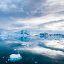
Climate change induced warming is happening faster in the Arctic than anywhere else on Earth. One of the critical factors controlling Arctic surface temperatures is the presence of low mixed-phase clouds (clouds that contain both liquid water and ice). At lower latitudes these clouds are short-lived as the presence of ice usually causes the entire cloud to freeze, but in the Arctic they can persist for many days. We want to understand the processes that sustain these clouds, why they eventually dissipate, and especially how changes in aerosols (tiny suspended liquid or solid particles in the air) may be driving the transitions between cloudy and clear-sky conditions.
To do this we are using a combination of observations from a permanent research station at Ny-Ålesund, Svalbard (78°N in the Arctic circle), traditional atmospheric modeling, and machine learning. The observations give us a detailed understanding of the conditions during cloud formation and dissipation at this site, and are also used for evaluating and developing the models. The models allow us to explore all the possible conditions that might occur across the Arctic, beyond the spatially and temporally limited observations.
We will first use a highly detailed three-dimensional atmospheric model called LES (large-eddy simulation), but these kinds of models take a long time and a lot of computing power to run. Therefore, we are also developing a machine learning model called an emulator, which will mimic the capabilities of the LES model and can efficiently test the sensitivity of Arctic clouds to the full parameter space we are interested in. This combined approach will allow us to understand the causal links between aerosols and Arctic cloud dissipation and optimize comparisons between models and observations.